De Okavangodelta, een uitgestrekt waaiervormig moerasgebied in de Kalahari-woestijn, ontvangt zijn levengevende water van een watertoren in de hooglanden van Angola. De animatie ‘Angolan Highlands Water Tower’ voor National Geographic, winnaar van de Map Design Competition 2023 van de Cartography and Geographic Information Society (CaGIS).
What lies beneath? Revealing the massive Hunga caldera (~ 5 km diameter) below the waterline. 3D model combining elevation data from American Geophysical Union (AGU) and bathymetrics from National Oceanic & Atmospheric Administration (NOAA) and General Bathymetric Chart of the Oceans (GEBCO). Rendered with Blender. Explore and download data here.
Vizualism animated the Delta Flume and designed the infographics for their corporate magazine. Using Sketchup, TwilightRender, Proper Animation and AfterEffects.
Watch the animation here.
Reconstructie van de schietpartij op De Dam op maandag 7 mei 1945 voor Vrij Nederland. Twee dagen na Bevrijdingsdag schoten Duitse mariniers vanuit hun hoofdkwartier aan de Paleisstraat.
#10 | Lazy stork gliding to his nest | De vlucht van een luie ooievaar naar zijn nest
Seizoen: Nederland van Boven 1
Aflevering: 10, Ondergrond
Uitzenddatum: dinsdag 7 februari 2012
Data: Universiteit van Amsterdam
Animatie: 422 South
#10 | Airplanes | Het vliegverkeer boven de lage landen
Seizoen: Nederland van Boven 1
Aflevering: 10, Ondergrond
Uitzenddatum: dinsdag 7 februari 2012
Data: VPRO
Animatie: 422 South
#9 | Roots invading sewer systems | Bomen en het Bredase rioolstelsel
Seizoen: Nederland van Boven 1
Aflevering: 9, Ondergrond
Uitzenddatum: dinsdag 31 januari 2012
Data: VPRO
Animatie: 422 South
#9 | Pipes and cables | Chaos onder de grond: kabels en leidingen door Rotterdam
Seizoen: Nederland van Boven 1
Aflevering: 9, Ondergrond
Uitzenddatum: dinsdag 31 januari 2012
Data: VPRO
Animatie: 422 South
#8 | Are we safe? | Risico-lokaties in Nederland
Seizoen: Nederland van Boven 1
Aflevering: 8, Gevaar
Uitzenddatum: dinsdag 24 januari 2012
Data: VPRO
Animatie: 422 South
#8 | Police Patrols | Patrouillerende politievoertuigen in de Residentie
Seizoen: Nederland van Boven 1
Aflevering: 8, Gevaar
Uitzenddatum: dinsdag 24 januari 2012
Data: VPRO
Animatie: 422 South
#7 | Old en New Residents | De wandelroutes van oude en nieuwe stadsbewoners
Seizoen: Nederland van Boven 1
Aflevering: 7, Wonen
Uitzenddatum: dinsdag 17 januari 2012
Data: VPRO
Animatie: 422 South
#7 | Growing City | De explosieve groei van een stad
Seizoen: Nederland van Boven 1
Aflevering: 7, Wonen
Uitzenddatum: dinsdag 17 januari 2012
Data: VPRO
Animatie: 422 South
#6 | Receding sea | De veranderende kustlijn
Seizoen: Nederland van Boven 1
Aflevering: 6, Vrije Tijd
Uitzenddatum: dinsdag 10 januari 2012
Data: VPRO
Animatie: 422 South
#5 | Red Deers | Herten in de Veluwe komen ’s avonds tot leven
Seizoen: Nederland van Boven 1
Aflevering: 5, Natuur
Uitzenddatum: dinsdag 3 januari 2012
Data: VPRO
Animatie: 422 South
#5 | Seagull visiting the capital | Texelse meeuw doet Amsterdam (332km)
Seizoen: Nederland van Boven 1
Aflevering: 5, Natuur
Uitzenddatum: dinsdag 3 januari 2012
Data: VPRO
Animatie: 422 South
#6 | The Perfect Storm | Noordwesterstorm leidt tot ergst denkbare overstroming
Seizoen: Nederland van Boven 1
Aflevering: 4, Vrije Tijd
Uitzenddatum: dinsdag 27 december 2011
Data: VPRO
Animatie: 422 South
De perfecte storm
De overstromingsgebieden
De schade
#4 | Walking the dog | Ieder zijn eigen wandelroute
Seizoen: Nederland van Boven 1
Aflevering: 4, Vrije Tijd
Uitzenddatum: dinsdag 27 december 2011
Data: VPRO
Animatie: 422 South
#4 | Queensday | Amsterdam kleurt oranje met Koninginnedag
Seizoen: Nederland van Boven 1
Aflevering: 4, Vrije Tijd
Uitzenddatum: dinsdag 27 december 2011
Data: Vodafone, gemeente Amsterdam
Animatie: 422 South
#3 | Survey planes | De luchtfotografen van Nederland
Seizoen: Nederland van Boven 1
Aflevering: 3, Knutselland
Uitzenddatum: dinsdag 20 december 2011
Data: Rijkswaterstaat, AHN
Animatie: 422 South
#3 | 80.000 farms | Agrarische bedrijven
Seizoen: Nederland van Boven 2
Aflevering: 3, Knutselland
Uitzenddatum: dinsdag 20 december 2011
Data: WUR Alterra
Animatie: 422 South
#2 | Ships in Rotterdam | Scheepvaartverkeer
Seizoen: Nederland van Boven 1
Aflevering: 2, Handel
Uitzenddatum: dinsdag 13 december 2011
Data: Port of Rotterdam
Animatie: 422 South
#1 | Cell phones waking up | Nederland ontwaakt
Seizoen: Nederland van Boven 1
Aflevering: 1, 24 Uur
Uitzenddatum: dinsdag 6 december 2011
Data: VPRO
Animatie: 422 South
#1 | Railway Traffic | Treinverkeer
Seizoen: Nederland van Boven 1
Aflevering: 1, 24 Uur
Uitzenddatum: dinsdag 6 december 2011
Data: VPRO
Animatie: 422 South
Toekomstvisie NS 2020
Voor de NS ontwikkelden we in 2006 een aantal illustraties ter ondersteuning van de toekomstvisie NS 2020. Deze schetsen werden later verwerkt tot animatie.
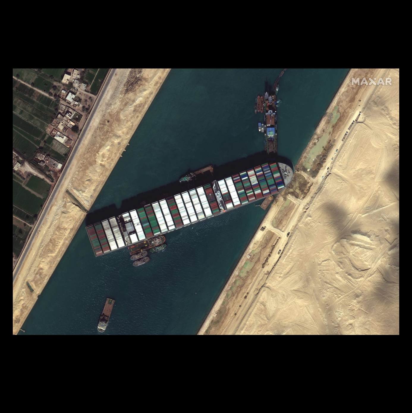
The Ever Given, operated by the Evergreen Marine Corporation, ran aground March 23 due to high winds from a sandstorm. The vessel is one of the world’s largest container ships. Fascinated by the story and curious about the incident, I tried to reconstruct the situation. The animation above is the most recent update thanks to comments by tweeps.
Reference material
Stitching satellite imagery of the area.
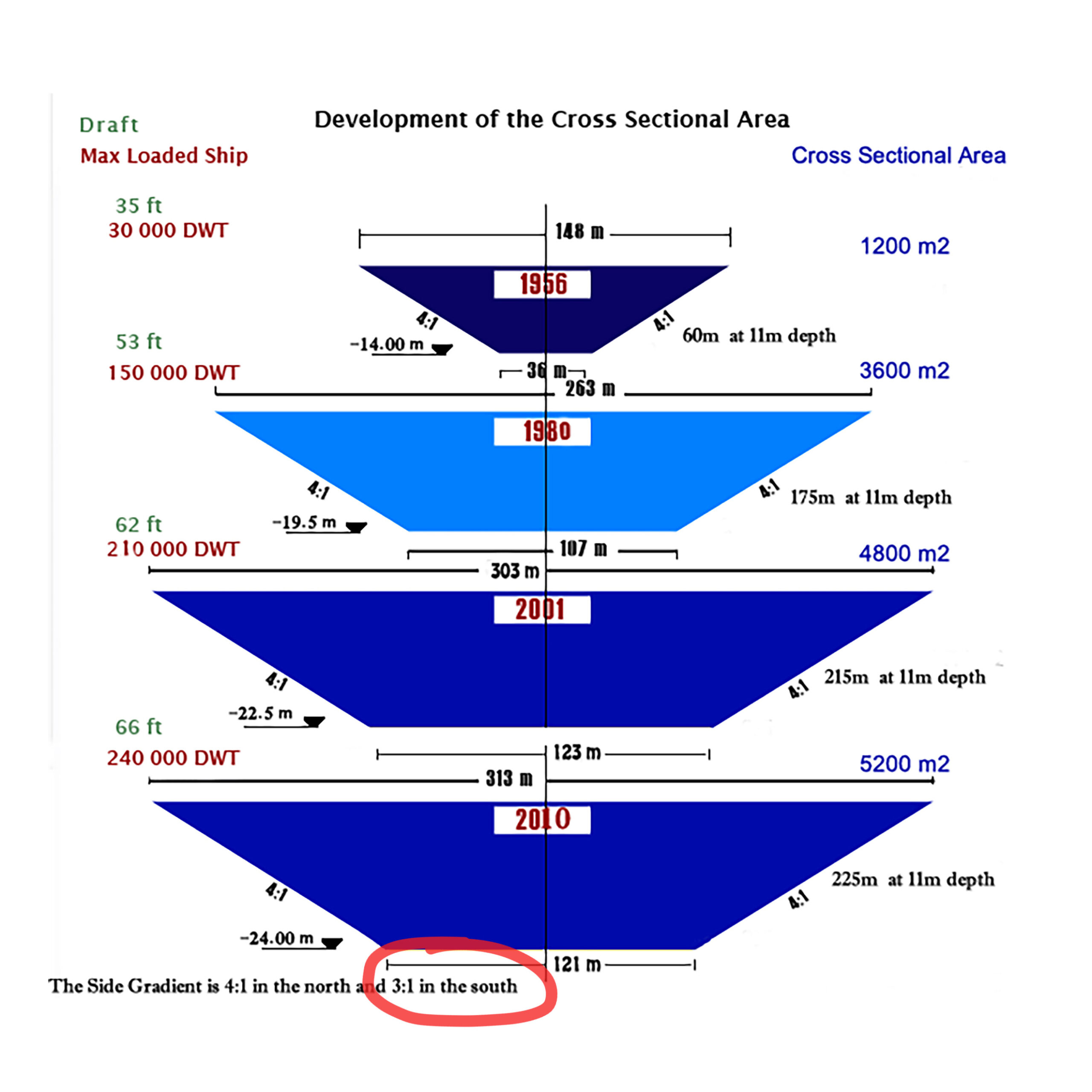
Searching for cross sections of the area (suezcanal.gov).
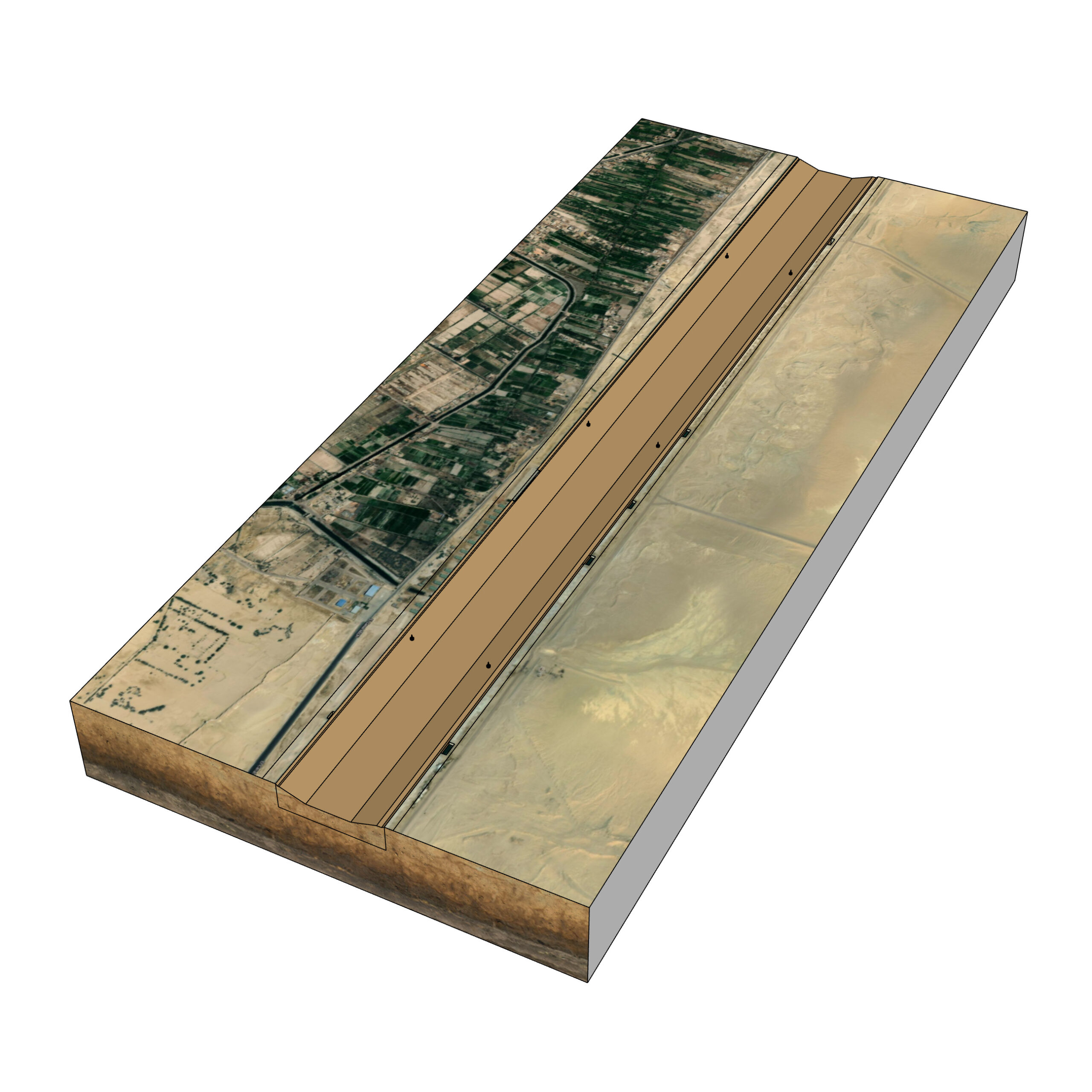
Drawing the area in Sketchup.
Using satellite imagery to pin point the location as accurate possible.
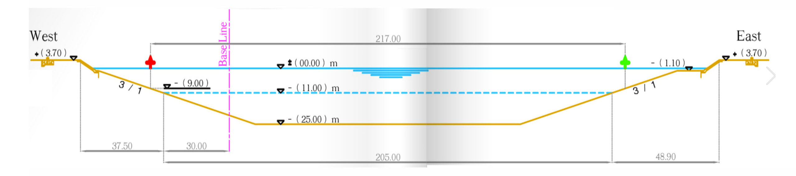
After tweeting the first animation, Suez Tug № 2 kindly shared the above engineering profile. It confirmed the 3:1 slope for the Southern part of the canal. Unfortunately at buoy KM 151 the situation is different:
John Scott-Railton kindly referred me to the nautical sonar maps on myshiptracking.com and showed me in the images above that the situation at that spot is very different than the previously mentioned engineering profile: “The actual canal is totally alive with silt and sand being pulled through…and stirred up by the passage of boats. (…) At buoy KM 151 the channel profile hugs the West canal bank, while the East bank of the canal is very shallow and silted (the blue part which is about 90 m). The boat is currently lying on a lot of muck (sand and mud) but.. the exact amount is probably only known to the people on scene.”
Based on the previously mentioned nautical sonar maps I generated a new cross section for the 3D model (B), which is indeed very different than the engineering profile (A) released by the authorities.