
Preview
Data
1. Storm dataDescription: DCSM-FM_100m_structuredAt250m_NorthSea_h6.nc Water level North Sea, Sinterklaasstorm 2013 |
|
2. CoastlineDescription: GeoTIFFs Paleontologische kaart (9000 v. Chr.) |

|
3. Eastern Scheldt barrierDescription: Pointcloud |

|
4. RoggeplaatDescription: Timelapse 2010, 2012, 2014, etc. |
|
5. Coastal transectsDescription: Kustverdediging 2010 – 2020 |

|
7. Ship tracks NOURISHMENTDescription: Suppleren (beach nourishment) |
|
8. Ship tracks DREDGERSDescription: Baggeren (dredging) |
|
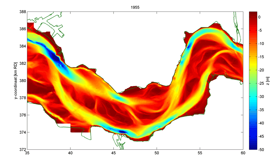
10. Bathymetry (timelapse)Description: bathymetrie 1955 – 2020
Download most recent (whole area) |
|
9. All ship tracksDescription: Scheepvaart |

|
11. Drowned Land of SaeftingheDescription: Timelapse Saeftinghe 2003 – 2020 (+ Hedwigepolder?) |
|
15. Tidal lineDescription: Tideline DCSM-FM_100m_0004_map[1-1154] |
|
16. Measuring stationsDescription: lat lon meetpunten- |

|
13. Survey planesDescription: tracks |
 |
14. SatellitesDescription: generated tracks |

|


